
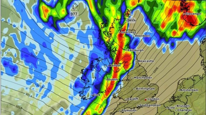

Britain is preparing for an imminent heavy rainfall event next week as a potent rainstorm moves across the nation, expected to bring intense downpours of up to 1cm per hour in various regions. Advanced weather modeling maps from WXCharts indicate that the storm is scheduled to arrive during the early hours of Friday, October 3, triggering torrential rain across several parts of the UK. The storm is forecasted to commence at midnight, with the initial heavy showers targeting areas such as the Scottish Highlands, Dumfries and Galloway, and parts of Edinburgh. Cities like Inverness, Aberdeen, Newcastle, and Manchester are also expected to experience early bouts of rainfall. Conversely, much of the southern region is likely to remain dry during the initial phase of the storm.
By 6 am, the rainfall intensity is projected to escalate across Scotland, affecting Edinburgh, Inverness, Dumfries and Galloway, and East Ayrshire with heavy rainfall rates of 1cm per hour. Additionally, the north-eastern areas are anticipated to receive significant precipitation. Meanwhile, regions in the south of England, Wales, and the Midlands might evade the worst impacts during this period.
As the day progresses, the storm is anticipated to move southward, bringing downpours to cities like Manchester, Birmingham, Cardiff, London, Southampton, and Newcastle as the rain extends throughout the country.
The impending storm follows prior warnings issued by the Met Office, which indicated that the beginning of the month would witness showers and prolonged rainy spells across various regions, with a focus on heavier rainfall in the north-west.
The Met Office’s long-range forecast for the period from September 28 to October 7 suggests a transition to drier conditions for many areas at the beginning of the following week. Although showers or longer rainy spells remain possible in all regions during the turn of the month, the wettest weather is expected to concentrate in the northwest of the country, with the likelihood of windier conditions in that region as well. Elsewhere, more extended periods of fine and dry weather are expected, accompanied by morning mist and fog patches in some areas, with temperatures generally around average. While uncertainties increase in early October, a similar weather pattern is anticipated to persist across the country.